


Listen to this post: Satellite Imagery, Open-Source Sleuths, and War’s New Transparency
Picture this: in late 2021, crisp images from Maxar satellites popped up online. They showed hundreds of Russian tanks lined up near Ukraine’s border. The world saw the buildup clear as day. No more fog of war. That moment marked a big change. Satellite imagery and open-source sleuths have torn down old secrets in battles.
Now, anyone can grab high-resolution photos from companies like Maxar or Planet Labs. Prices dropped as more satellites launched. OSINT experts mix these shots with phone videos, Telegram posts, and ship trackers. They build live maps faster than news crews arrive. In Ukraine, this combo exposed lies and guided aid. In Gaza, it tracked shelling paths.
The upsides shine bright. Truth spreads quick. Atrocities face daylight. Aid groups dodge dangers. Yet pitfalls loom. Armies now use decoys and jams to fight back. Wars drag into slow grinds, not bold pushes. As of January 2026, Ukrainian drones hit deep into Russia, with satellites spotting the blasts right after. Militaries scramble to adapt.
This new openness reshapes fights. Public eyes watch every move. Let’s break down how it works.
How Commercial Satellites Bring Wars into Plain View
Cheap satellites flood the market with fresh views of hot zones. Firms snap the globe daily. Governments buy them. So do reporters and aid workers. Old spy agencies once held the keys. No longer. Data pours out for all.
Take Maxar. Its pictures proved vital in Ukraine. A brief US pause on sales in 2025 left gaps. Strikes missed targets as a result. Planet Labs fills in with constant scans. Ursa Space pulls from 22 providers. It flags ship jams in the Gulf or troop shifts in Gaza.
Shelling patterns emerge from these orbits. Watchers spot Yemen drone paths too. Satellites count tents in camps. They measure craters after blasts. No cloud hides the scars. This boom stems from launch costs plunging. Hundreds orbit now. Images arrive in hours, not weeks.
In Gaza, repeated strikes show up stark. BBC Verify’s analysis of hospital attacks used satellite shots to map four hits in one day. Heat spots confirmed the blasts. Such tools turn blind spots into spotlights.
Maxar and Planet Labs Lead the Charge
Maxar rules high-res shots. Posts on X share its Ukraine snaps. They reveal training drills and border walls. One set caught Russian pontoon bridges mid-build. Days later, Ukraine blew them up.
Planet Labs scans earth each day. Its doves swarm in flocks. Front lines in Ukraine shift slow under their gaze. Rebels buy images too. Ships track rivals at sea. Prices suit small buyers. A single pass costs little. Data stacks build the full picture.
Firms thrive on open sales. No clearance needed. This levels the field a bit.
Ukraine Shows the Power in Action
Back in 2022, Maxar tanks tipped the scales. The world geared up. No surprise hit landed. Daily feeds now guide drones. Spot a convoy? Strike it.
Fast-forward to January 2026. Satellites caught oil depot fires in Russia’s Yaroslavl after Ukrainian drones flew deep. Crimea ammo dumps smoked too. A 2025 data pause hurt. Strikes flopped without fresh eyes. Drones rule a 10-15 km kill zone now. OSINT pins exact spots.
Winter slowed Russia in late 2025. Gains shrank from 276 to 89 square km in December alone.
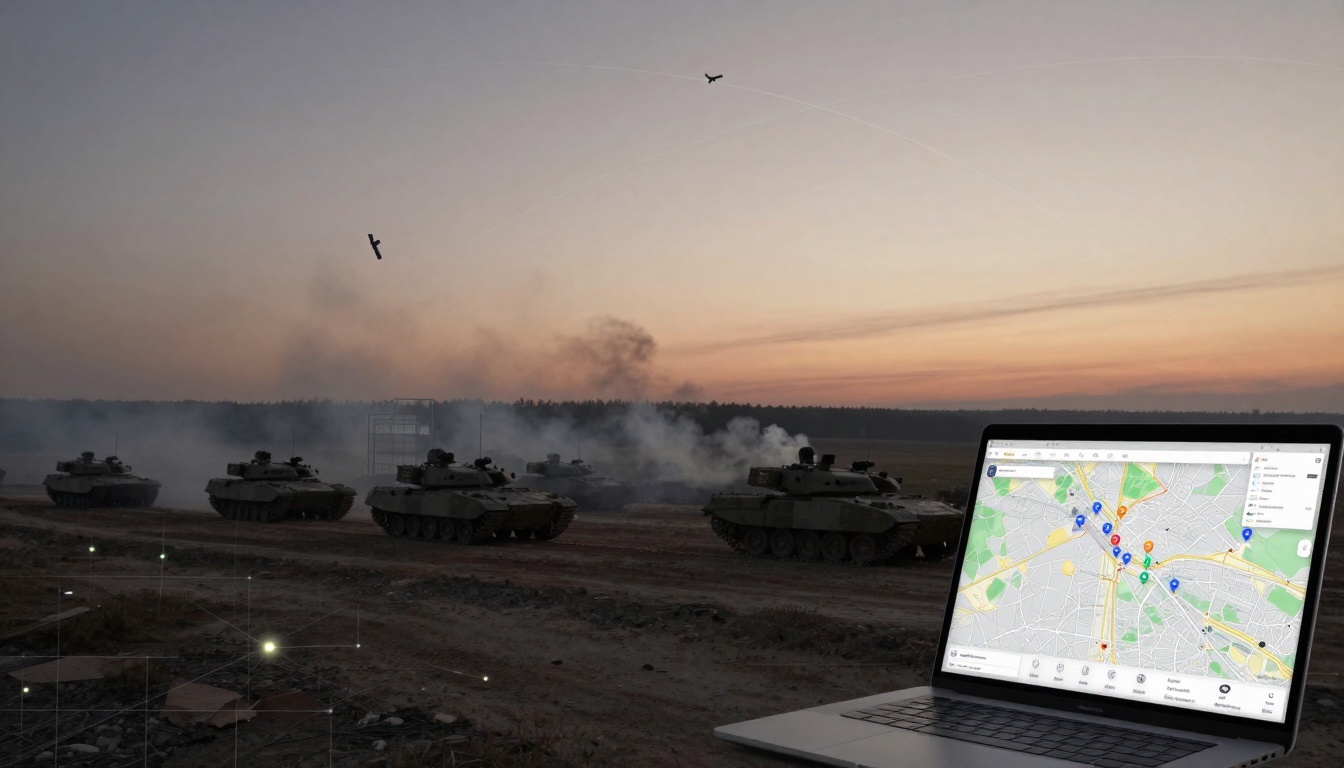
Open-Source Sleuths Turn Data into Battlefield Maps
Volunteers stitch scraps into gold. OSINT sleuths grab satellite grabs, dashcam clips, and chatter from chats. They pin it all on maps. Updates roll like weather apps. No paywall blocks the view.
US NGA’s Tearline shares clean data. Journalists nailed Russian crimes in Ukraine with it. Gaza aid trucks snake safe routes thanks to these maps. Yemen strikes get called out fast.
Challenges bite. Lines blur in fog or night. Fakes slip in. Yet sleuths cross-check. A phone vid matches a sat pass. Boom. Truth holds.
An open-source tool maps Ukraine’s ruins at scale. It tallies shell craters from orbit. Volunteers feed it ground proof.
Key Tools and Teams Driving OSINT
Tearline leads unclassified shares. Ursa blends feeds for alerts. News teams like BBC Verify fuse it all.
Daily maps track Ukraine pushes. Gaza damage tallies hit 31 October 2025 via UNOSAT assessments. Yemen watchers log Houthi moves.
Sleuths log nine deep Ukrainian drone hits in late 2025. Satellites then showed Russia rush air defenses to Alabuga.
The Double-Edged Sword of Open Battlefields
Open skies aid the watched. Ukraine called out false claims. Videos proved they held ground Russia stole on paper. Aid in Gaza picks clear lanes. Strikes land true.
Atrocities sting in light. Shelling maps shame denials. Public pressure sways aid flows.
Yet openness bites back. Armies hide smart. Ukraine turned to attrition. No big flanks. Drones own the air.
Pentagon inks sat deals now. All chase the edge.
Wins for Truth and Tactics
Lies crumble fast. Russia claimed wins; geoloc vids showed otherwise. Aid dodges traps in Gaza. Ukraine targets deep with proof.
CSIS notes tech shifts on battlefields. Truth aids the defence.
New Hiding Tricks Armies Must Learn
Decoys fool counters. Fake tanks dot fields. Jams blind drones. Info floods swamp sleuths.
Russia parked trucks at nukes, hid by snow match. Overload buries real moves. Wars grind slow.
Satellite imagery and OSINT sleuths usher in war’s new clarity. Fights play out live for all. Militaries chase shadows in hider-finder chases. Drones probe deep; sats catch the smoke.
Public watch stays sharp. Adapt or lose. Follow CurratedBrief for tech shifts in global clashes. What blind spot will break next? The sky sees most. Stay tuned.
(Word count: 1487)